As I drive to the LISR bridge, vestiges of civilization drop away. Before I got to Fenske Lake Campground telephone poles had stopped following the road. After a few miles, the pavement ends and I continue on a gravel road, which is actually smoother than the pavement. After an hour drive, I park in the little parking lot at the bridge--no other cars. This probably means that I will have Bootleg Lake to myself. Only one group every other day can enter here. It's possible, but unlikely, that many people will come to Bootleg from either Cummings Lake or Little Trout Lake via the LISR.
I unload my van deliberately; I don't want to forget anything. All my camping gear and food goes in my dry pack. I have moved the seat and thwart of the Hornbeck forward a few inches to trim the canoe with 52 pounds of gear behind me. The spray skirt is designed with two strips of Velcro so that it can either cover a pack or be kept tight over the empty stern area of the canoe. I close it up using the forward strip. I present a low profile to the wind since I sit on the foam seat in the bottom of the canoe; the spray skirt improves this even more.
The word "perfect" keeps coming into my mind as I begin to paddle upstream. The sky is a bright blue with no clouds. The morning light brightens the spring colors in the leaves. There is no wind. The current is hardly noticeable. I am alone on the river.
Soon I cross the boundary of the BWCA and a light wind from the southeast begins to build. I suspect it will go become stronger and remain in my face all day. I also suspect it will become northerly for my return paddle. I fire up my GPS and am glad to see that the combination of wind and current is not slowing me very much. With my average steady stroke I am doing around 4 mph. I have put in the coordinates of the portage trail to Bootleg Lake using Delorme's Topo USA. I query the satellites to see how far it is; the answer is meaningless because of all the meanders in the river.
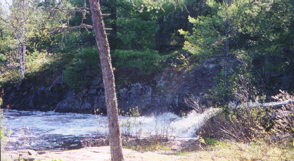
Side view of Sioux Falls which are bigger than they appear here. Note foam that fills a pool to the left.
Sioux Falls is the first portage; I've paddled 1:15 to get there. There is a large, foam-covered pool at the base of the falls. Suddenly a mature bald eagle with a brilliant white head flies away from a dead tree at the top of the falls. The falls are about 12' high--this drop doesn't happen at once. The water flows down over several large rocks with a loud roar. A large volume of water shoots through here. The river is perhaps thirty-five feet across above and below the falls; but the falls themselves are only about ten. The portage is very short (8 rd.) and I do it in two trips; I judge it to be faster to do this than to install my portage yoke. On the second trip I see a large (30"?) northern right near shore. The eagle knows where the fish are.
Half an hour later I leave the portage around the second set of rapids. Again an adult eagle flies away as I approach the portage. This portage is straightforward; a pretty good path parallels the rapids for about 100 rds. This is the first time I use my new, raised yoke. It works well, although I know I will get tired of tightening the knobs at each portage.
About two hours later I pass the confluence of the Little Pony River and the LISR. I plan to come down it in a few days. But today I'm taking the longer route to Bootleg Lake. I think that most people go up the Little Pony to Bootleg because it is shorter. But I want to see as much new territory as possible so I continue up the larger river. I notice no change in the current, although the LISR is already becoming a bit narrower.
In another hour and a half I push off from the portage around the next set of rapids. A bald eagle, immature this time, flies away as I paddle through the foam at the base of the rapids. In July 1999 I had great difficulty finding this portage since the water was much lower. You have to paddle against a strong current between several rocks to get to the trail, which barely has a level place to stand before climbing up among some large pine trees. Fresh wolf scat is in the trail which has several end points. I take the first one and have to hold my canoe in place with one foot while I take off my pack and place it in the canoe. The other upstream put-ins are better in lower water but very muddy now. I come close to having water go over the top of my 17" Tingley boots but just manage to keep my feet dry.
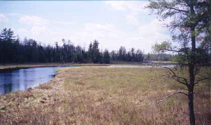
LISR looking south from the Bootleg portage. This is the portion of the river where my GPS accurately guided me to the trail. This is a typical view of the river--bog plants and spruce and pines on a basically flat landscape. I'm a little way up the hill that must be crossed to get to Bootleg Lake.
The wind has increased and it begins to affect my speed; the GPS reports that I'm now paddling at about 3 mph. I'm not surprised: the current is a bit stronger and four hours of paddling and portaging have taken their toll. About five hours after I left, I reach the Bootleg Lake portage. I turn on my GPS to evaluate its ability to guide me to a certain point. I know what the portage looks like from my 1999 trip. The GPS is amazingly accurate; it guides me right to the trail. This is a 200 rd. portage which slowly ascends a rocky ridge and then descends to Bootleg L. I take a lunch break and then do the portage. I keep an eye out for ExitB's hat but do not see anything but moose tracks and wolf scat. I arrive at he southern campsite 6:20 after I began. I've covered about 15 miles.
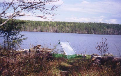
Here's my camp on Bootleg. Doesn't it look perfect? Trees just coming out, sunny, warm and, I've forgotten to mention, no bugs! By the way, I haven't put the fly on my tent yet.