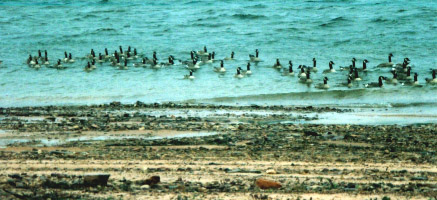
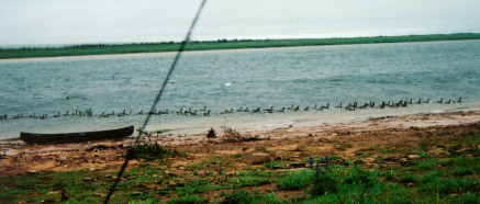
Cold wind and rain from the east forced us into our tent after only covering five miles. Hearing a great deal of honking, I looked out of the tent and saw 72 geese checking us out. The strength of the wind can be judged by the wave. This is also a good shot of a typical section of shore line. There are lines made by ice moving downstream. There are also marks made by the river as the level receded after the spring thaw.
Wind Bound Among Seventy-Two Geese
We awoke to a gray day with an east wind. Today was July 12th and our pickup was scheduled for July 15th at noon. We estimated we were about 35-40 miles away at this point. We weren't worried because we had done 30 miles a few days ago. But the weather was the worrisome factor. Paddling 40 miles into a stiff headwind would not be easy.
So I started off in the stern determined to paddle around 12 miles at least. We paddled about 5 miles generally to the northeast but then we turned almost due east. The wind was directly in our faces. Waves with a few white caps splashed over the bow. Most of my paddling energy went into keeping the bow into the wind. We kept watching the shore where our progress was barely perceptible. We kept paddling but the wind blew us right up against the shore.
Since we had stopped we decided to take a break. Rain had started to come down and we put up the shelter and sat under it for a while and kept checking the barometer, hoping to see it start to rise which would signal the passing of the low pressure area. But it kept falling which meant that the storm was still approaching. We had a warm lunch. The weather still did not improve. We were a little damp and cold by this point and decided to set up the tent.
We put it up on the shore. It was a bit rocky but it showed that you could literally camp anywhere along the river. We resolved to leave early in the morning no matter what the weather. We had a relatively short distance to travel east and then had a much longer stretch to the northeast. We hoped that the wind would at least change direction while we slept (I couldn't really call it night).
Campsite coordinates: 13 W 037090, 715125.
72 Geese proceed upstream and downwind past our windbound canoe. Normally geese kept their distance but since we weren't moving, they approached.
After finding the remains of a moose antler, we paddled again. We were on the lookout for Waterfall Glade, an area that has a warmer microclimate that allows plants that are not usually found this far north to grow. We ate lunch at a place that had a small stream tumbling into the river and some raspberry plants and violets. We continued on and found the real Waterfall Glade, where a small stream cascades off a cliff. It is noticeably warmer in the narrow canyon near the falls. The mosquitoes were very bad and we didn't linger.
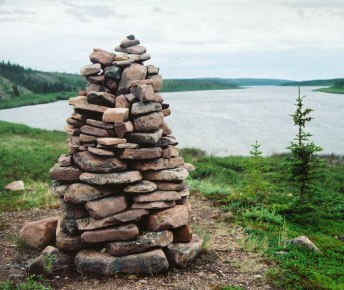
A cairn built by the first recreational canoeists in 1962. We found a note from 1996 inside.
Soon we came to a cairn built by the first recreational canoeists in 1962. Inside was a note from some Norwegians who had passed through in 1996 on their way from Yellowknife to Baker Lake. I added a note about our much shorter trip. By this time it had begun to cloud up. When we finally found a suitable campsite, we had to set up the tent and shelter in a light rain. We picked a site that apparently was popular. We found several fire rings and a path was worn through the stones along the bank. It was dry tundra but the ground was somewhat uneven and it was a little hard to find a level place for the tent. We disturbed some kind of sandpiper who sat in the top of a nearby tree and made a continual call for a couple of hours. We also found a patch of caribou hair.
We had been cooking our own meals but on this night split a Cache Bay wild rice salad. The wild rice took a good while to cook and the rehydrated "salad" was a little strange--chewy and warm. I added a piece of pita bread with melted cheese, cookies from BackCountry.org(anic) and most of Mo's pudding. After all this, with the mosquitoes becoming more intense and more wind and light rain, we happily retired to the tent. Once we had removed all the mosquitoes, we happily relaxed.
Technology Update Just before I entered the tent I decided to use my GPS to mark our campsite. But when I turned it on the screen showed only a few weird wavy lines and then went completely blank. The Garmin 38 is advertised as waterproof and I had once dropped into a lake in Minnesota without any problems. But the ride in my canvas daypack, which had gotten a good soaking on the Radford River, was too much for it. In the tent I got out my small tape recorder that I used to amplify my journal notes. But it would not record. Sand had probably jammed the mechanism. Then I tried my little map measurer (a dial attached to a small wheel); but it would not turn as I moved it along the map. I had also given up on the satellite phone and could only hope that my wife would realize that there was some technical problem and not worry. Mo and I agreed Mother Thelon decided that, if we said we wanted to leave the modern world behind, we would indeed leave it behind. In the morning Mo's watch strap broke and I began a game of having him guess what time it was--he rarely was close.