We awoke knowing that we had to move in order to cover the thirty-eight miles to the pick-up point in two days. In spite of wind, rain or cold we had to make some progress down the river. Thirty-eight miles was too far to leave for the next day. There was no assurance that the weather would be any better that day. Our only cushion was the 12:00 noon pick-up. We could, if we were really stranded, paddle that morning. We also were not restrained by darkness. Although we had not done it, we knew that there was enough light to paddle even when the sun was below the horizon from about 11:00 p.m. to 3:30 a.m. We put these alternate plans out of our minds and began the day on a regular schedule and hoped that we would end on one.
The wind had shifted to the northeast but had not diminished in twenty-four hours. The barometer was rising--a good sign. We had, however, noticed that changes in air pressure did not translate into actual weather for a long time. Since the majority of our route was to the northeast, it was immediately obvious that this day would be hard. Our goal was the uppermost tip of the Ursus Islands where the river made a 90 degree turn to the southeast. If we could get to that point, we would no longer have a head wind.
We towed the canoe where we could walk along the bank and paddled into the wind where we could not. It was tough and our progress was slow. Finally we came to a point with an opening to the southeast. We eagerly turned into it and let the wind blow us. We left the main current to go around a small island and were surprised when the river dwindled to almost nothing. We rejoined the main flow but it still seemed smaller than before. Our maps showed large lakes and we thought that they were absorbing most of the river's flow as the level of the river dropped after the spring thaw. We also wondered why we were going so slowly with a tailwind and the current. I had a compass in the bow and Mo had the map in the stern. I would call out our direction randomly. I saw we were going southwest which I didn't remember, but I didn't have the map to check. Other things suddenly didn't make sense. The best example was some snow on a mountain. I had watched it carefully as we paddled into the wind to judge our progress. It had been on our left. But now it was on our right. How was this possible?
We stopped and got out all the maps. The Ursus Islands were at the corner of 4 maps (the 1:50,0000) and it was a little hard to get the overall picture. But looking at them we had the scary realization that we didn't know where we were! We weren't even sure which way the current was flowing. We dropped sand into the river but came up with contradictory readings; we knew that eddies could confuse us. Finally I found an ice-bent bush on the riverbank that clearly showed that we were going upstream. We could not find a place on the map where we could go upstream and southwest.
Many thoughts like these ran through our minds: if only the GPS hadn't gotten wet, if only the satellite phone worked we could call the pilot, would the pilot look for us or just turn around? We finally decided to go back (downstream we thought) to where we had eaten lunch (hot because we thought we were making great time). There was a good current there and we thought we could at least be certain of the direction of the flow. If we went downstream, we would eventually get to the pickup point.
Suddenly things looked very familiar to me. I said, "Mo, we've been here before!" He was skeptical. But I suddenly saw my footprints in the sand and a place where I had peed. This cinched it and Mo was convinced. Things mentally fell into place. We had taken what showed on the map as a dry riverbed almost back to our starting point. We had paddled for nine hours and had only progressed a mile or so. Feeling stupid and very tired, we reversed out course and went back down the "dry" river. Three hours later we arrived at the true turning point, the northernmost point of our trip. The last half hour of paddling was really rough. There was a light headwind. We took a break. Mo said he really didn't think he could paddle much more. The muscles in his neck and shoulders were cramping. My left shoulder wanted to come out of its joint and I had to hold the paddle at a certain angle to avoid pain. But I said, "We'll feel so much better if we get to that point." We pushed on and finally turned the corner.
We ate quickly and fell into bed as the sun set at 10:45 p.m. The wind had almost stopped and it was mostly sunny. We vowed to rise early and get started on the twenty-four miles to the pick-up point. We also pledged to have the map and compass in the same place in the canoe. We did not have any time to waste on our last day.
I forgot to mention that we saw a large black bull moose while we were paddling into the headwind. Instead of crashing into the brush, this moose decided to outrun us and raced down the beach ahead of us before turning into the brush. We had a great long view of him. We saw him again (we think) on our detour. We fantasized that if he had had any experience with canoeists he was surprised to see us heading in the opposite direction.
Summary of the day: 12 hours of paddling to get 14 miles closer to our final camp. I don't want to calculate how many miles we really paddled. Campsite coordinates: 14 V 038195, 715990.
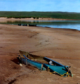
Crushed Canoe Camp
When we finally reached out campsite, we were surprised to find this canoe. A group reported it was here in 2001. Email me if you know the story
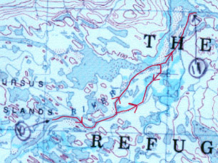
A map of our "Great Circle Route": Start at camp 10, northeast into wind, turn southwest and go until disorientation sets in, back track and eventually get to camp 11. (This 250k map shows water in the "dry" river.)
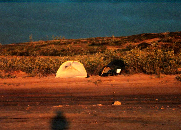
11 pm Sunset: We finally get to rest! (Mo is already in bed).