300 Miles into the Barrens: Life Jacket, Paddles but No Canoe
The Float Plane Base turned out to be a couple of small buildings, a dock on a lily-covered lake and several planes. Sandhill cranes cried in the distance. We unloaded the taxi and headed toward the dock with high expectations. This was the end of planning that began in January. We had talked with Doug, the owner, and his wife Linda several times and on some level were expecting a big welcome. But this was just another day of work for the crew. It was also Canada Day, a national holiday. They were working. They didn't share our excitement.
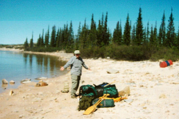
A guy finally started asking us where we were going and began to talk about the kinds of things we would see. He suggested we put all of our stuff on a big scale built into the dock and then we stepped on. The moment of truth--596 pounds!
We went into the building expecting to pay. Another guy in a blue jumpsuit gave us a flight plan form to fill out and turned to study the map on the wall. He seemed a little unsure of where we were going. He also asked about the pickup. We were a little vague about exactly where. Weren't they supposed to know that? Our "friend" from the dock came in and said that most people were picked up in a straight stretch of river just before Hoare Point. The pilot seemed to digest this for a moment and then said, "Let's go."
We headed for the plane. The crew had already loaded our stuff. They had started with the smaller packs. We couldn't get to our cameras; they were buried under four large dry bags paddles and life jackets. It was Canada Day; the crew was not inclined to unload everything. I looked at Mo and he shrugged and we climbed aboard.
The three-hour flight to the Radford River was incredible. As we flew northeast, the thick forest around Ft. Smith thinned out as we approached the tree line (which is not as well defined as it appears on some maps). Lakes, ponds, creeks and rivers were randomly scattered in the vast evergreen forest. We saw large areas of it that had been burned. Some was growing back with many green shoots among the black ashes and other areas were recent and mostly black. The rocks were pink and gray where the lichens had been burned off. It will take about 80 years for them to grow again. We saw moose, beaver lodges and then, farther north, long sandy eskers with caribou trails. We also flew over a prison where inmates fish and generally get in touch with the natural world.
We flew over a large lake that was largely ice covered. Another plane appeared and flew directly underneath us. We listened as the pilots discussed where fuel caches were. In chatting with our pilot we learned two interesting things: 1) the guy we talked with at the dock was not an employee but a professor who liked to see groups take off, 2) our pilot had never been farther north than 51°. We took off from near 60° and had gone north. No wonder he was studying the map! A guy just hanging out at the dock had determined our pickup point! Another cause of concern--we had been fighting a 45-knot (52mph) headwind and the pilot kept checking his fuel consumption.
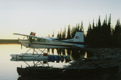
We began our descent to the Radford River. I asked the pilot if he could take us over Dickson Canyon that is on the Hanbury River. It reputed to be beautiful and we were debating whether we should hike over to it. It was about 5 miles away. But the pilot said that he was worried about his fuel and wanted to land. He did, however, make a large circle around the lake and we saw that the river exiting the lake was not a swamp as we feared but actually had some white water. We landed and taxied toward some 55-gallon barrels of fuel (belonging to another company) that marked the location of the canoe. I pulled on my hip waders and pulled the plane to the shore. Mo and Ian, the pilot, followed. But after several minutes of searching, we could not find the canoe.
We came back together and widened the search. Mo and I donned deet and made a larger circle in the woods. Ian roamed out sight down the beach. He returned sweaty, hot and covered with mosquito bites. He got out his Global Star satellite phone and called Float Plane Base. It was Canada Day. Nobody knew anything and the boss was in Yellowknife. After much discussion, Ian decided to take the initiative. We heard him,
"The canoe is not here. These guys have to have a canoe. I'll fly back, get one and fly back."
Mo, who had begun his 30-day Noatak River (Alaska) trip, by forgetting to buy Coleman fuel, asks, "Where's the canoe?"
Soon Ian was airborne. He made one more low circle completely around the lake before disappearing to the southwest. Mo and I reflected on our situation. We were about 150 miles from the nearest town. There were no roads. Hiking even 150 yards through thick trees and brush to look for a canoe was difficult. We had to have faith that he would return with a canoe. It was a 3-hour flight to Ft. Smith, another hour to refuel and tie the canoe to the plane and 3 more hours to fly back to Radnor Lake. I estimated he would arrive about 10 pm.
Camping becomes easy when a routine, a rhythm is established. When each person does the same job automatically, set-up, for example, becomes a ritual that connects one campsite to another throughout the whole trip. Since Mo and I had only known each other for two days, it took a while to get to this place. We started with the brand new tent, an Alaska Guide 4 man model from Cabela's, and began to learn the color code system to put the seven poles in the right sleeves. Then we moved onto the cooking tent. It had 3 poles and needed 9 ropes tied to 3 stakes. Then netting had to be attached to the Velcro I had sewn on. Then we "hung out"-- walking along the shore, studying bird books and looking at various birds in the spruce trees
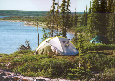
We have it all: a sunny day, a lake, a view of the Barrens, a grove of Spruce, a cook tent and a sleeping tent (green). But no canoe!
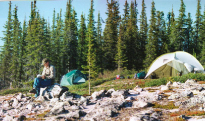
Shipp studies his bird book while we await the arrival of the canoe.
Mo was a little skeptical of the cooking tent and when we cooked our meal opted to cook outside. I cooked inside and was glad to see that, as many had predicted, most mosquitoes inside spent their time trying to get out. Mo wasn't terribly bothered outside. About 8:00 the mosquitoes really started coming on and we retreated to the tent to talk. About 10:30 we heard the plane. We were glad to see it had a canoe tied to the outside! The pilot had filled the cabin with jerry cans of fuel. We chatted while he poured them in. Nobody had any idea where the canoe was. He was happy that the ground crew had had a pizza waiting for him when he got back. The sun was finally going down now at about 11:00. We offered Ian a place in our tent but he said he would just sleep in the plane (less mosquitoes) and would be up early and fly out around 6:00 in the morning. Lastly, we agreed on a pick-up placeat the "v" in River on the 1000 m. map near Hoare Point about 200 miles away.
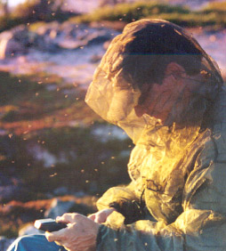
Shipp uses his GPS to find his location--he's in a cloud of mosquitoes (9:00 pm).
We retired for our first night in the wilderness. We were surprised how quickly it cooled off once the sun set. Even though it came back up around 3:30 am, we slept with fully zipped sleeping bags. The thick permafrost quickly cools the air when the sun is not present.
Another theme of this trip began during this timethe breakdown of technology. I decided to fire up the Iridium satellite phone I had rented. The conditions on the ground were excellent; few trees blocked the view to the sky. I dialed my home number and in just a few seconds my wife answered. I could hear her with only a slight echo; but she could not hear me. She kept saying, "Hello, hello. Shipp, is that you?" Then she hung up. I read over the directions and dialed again. Same result. I became frustrated. I didn't worry about the safety issues; I just wanted the phone to work. My mind began to think about solutions and soon I might as well have been at home trying to solve some computer problem. I was no longer looking at unusual birds in the trees. I was thinking what buttons I should push on the phone. I tried calling the phone rental company's technical number. "Hello, hello." My frustration was very obvious and Mo also wisely saw that it was taking me out of the wilderness and putting me back in the technological world. He advised me to put the phone away and stop thinking about it. He told me to forget I even had it. I wasn't quite able to do this; but I did pack it away and tried to immerse myself in the beauty all around
It's getting dark, but we have a canoe!
Next page--click below:
In Great Heart Davidson and Rugge give a great description of the " insect peril. Some
readers might suspect us of exaggerating their numbers and their ferocity, but anyone
who has ventured into the North during the summer months will recognize our actual frustration: that the human mind is not built to conceive such numbers and written words do not exist to convey the torment they inflict. Furthermore, the farther north one proceeds the worse the menace becomes. Both mosquitoes and flies breed in waterblack flies in swiftly flowing streams, mosquitoes in stillwater and large areas of the Canadian shield lie under water. In the permafrost of the tundra, frozen ground only inches below the surface prevents meltwater from freely draining, and so in addition to the numberless ponds and lakes, breeding mosquitoes may select from an infinity of
puddles and marshes. As for the black flies, several hardy entomologists once made
a formal estimate of the number of black fly eggs on a single fifteen-foot stretch of
rock beside a northern waterfall. The total? Sixteen billion. (See Robert Stewart,