Shipp & Mo's Thelon River Expedition


Ian fired up the plane at about 6:00 am and took off.  We wanted to offer him some coffee but, since we hadn't bedded down until midnight, we dozed for a while and waited for it to warm up a bit.  Besides Ian had the remains of a pizza for the trip back to Ft. Smith.
Wilderness canoeing these days involves a mix of the ancient and modern.  Distance is covered by the physical exertion of lifting and pulling a paddle thousands of times; but the starting point is reached by airplane which hardly requires any effort.  You are more exposed to changes in temperature, amount of rain and wind; but these are somewhat mitigated by nylon tents, down sleeping bags and windproof jackets.  The early explorers had very little idea of what to expect.  We had read books and Internet reports.  They knew only vaguely where they were, mostly just their latitude.  We had a GPS and 1:50,000 maps. Our trip moved along a continuum between ancient and modern; sometimes we did the old, old things like paddling other times we were thoroughly modernplotting our position with GPS and mostly we did a mixture.
We began our first day of paddling firmly at the modern end of the scale.  We knew precisely where we were and had a detailed knowledge of the route ahead, not only from our maps but also from flying over the first part of our route as we landed.  We were also well fed and had rested warmly away from the bugs in our brand new tent.  As we paddled toward where the river narrowed, we also began to move toward the ancient end of the scale.  The current increased and formed large sandbars that we were able to float over.  Each one had at least one huge (and ancient) lake trout that was busily eating things carried down by the current.  The current increased a bit more as rock walls began to rise on either side of us.  We had seen one long chute from the plane and were surprised when we saw a large area of white water ahead of us as we made a left turn.  A huge rock rose in front of us with water dividing to each side.  Mo (in the stern) yelled, "Power, go left."
I was able to get the bow past the rock but heard a yell when I judged the stern was also past.  I turned and was surprised to see Mo up to his neck in the water.  I started to paddle toward the left bank and stupidly stopped to grab a package of what I thought was medicine.  Mo eventually grabbed the canoe and we were able to get it to shore just above another large drop.  Mo was very quick to realize that I could not have gotten the canoe beached by myself and suffered some cuts and bruises on his knees and shins as he swung the canoe toward shore.  I realized we had no bailer and used a cooking pot to empty the canoe while Mo tried to dry off and warm himself.  The ice had just left this area about two weeks before and the water was still very cold.  Luckily it was a sunny and warm day.


Rapids?  There Are No Rapids on the Map!
By Shipp
The rock surrounded by white water catapulted Mo into the chilly water.
by Shipp
Mo, "We should've scouted."
by Shipp
We took stock of the situation.  We were about one hour into the trip and had broken two important rules.  We had not scouted a rapid before running it.  We had believed the map (modern) over what our eyes told us (ancient).  Mo had not been wearing his life jacket. 
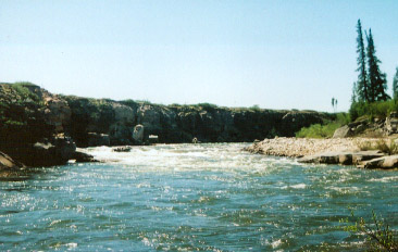
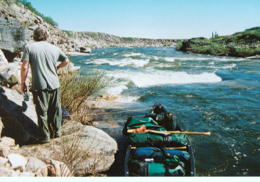
We now scouted the remaining rapids by looking downstream.  We decided they approached a Class III.  We walked along a narrow ledge and lined the canoes.  This was also an adventure.  The canoe teetered on a curling wave and almost tipped.  It took on a good deal of water that we bailed out.  We next came to a large falls that necessitated a short portage.  We walked overland across the next bend and saw that another set of rapids awaited us.  We easily lined this one on the left and floated down to the confluence with the Hanbury River.
I had read of a cairn at Helen Falls, which was in sight up the Hanbury.  It contained some notes left by various explorers and I wanted to read them and add my own.  We paddled across the current of the Hanbury and then walked upstream.  But a deep cold stream blocked our route up that shore.  I took off my boots and zipped off my pants but the water was scrotum shriveling cold and deeper than it looked.  Mosquitoes went for my tender flesh and we turned back deciding that only those people who descended the Hanbury with all its portages and rapids were entitled to leave a note in the cairn.
We proceeded down river without incident.  We passed a gyrfalcon nest where one of the parents made a loud racket and also passed an empty nest of some type of raptor high on a cliff.  We found a nice sandbar in the middle of the river and camped there.  We had traveled about 7 hours and were tired from our adventures in the rapids.  We had traveled about 18 miles.

Next: Warden's Grove, The Gap, Grassy Island.
First Thelon Page
< Back    Next >