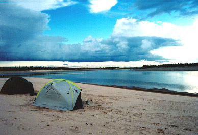
One of my favorite campsites. Wolf tracks on the beach, tool-making chips on the higher ground, a thunderstorm approaching and a great view of tomorrow's travel.
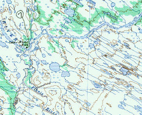
Not only did Lookout Point mark the division between the Chipewyan and Inuit land; it also marked the beginning of some unique geology. All streams and small lakes beyond Lookout Point run is straight northwest/southeast lines. On the map or from the air they are as straight as the roads you see flying over southern Minnesota or northern Illinois. We were not aware of it from ground level.
The river widens out and we paddled down long straight stretches. We were ready for more big mammals. But Mother Thelon willed otherwise. We mostly saw many goose parades. Geese flapping and trying to get airborne, then swimming downstream as we approached, then crashing up onto the bank and finally running ahead of us and ducking into the brush. I had never read of this phenomenon in other accounts. I think it is so common that the writers skip over and tell of more unique experiences. We found it very entertaining and on this day it was about all we had to look at. There was sameness to the riverbare rock along the shore where ice had scraped away all vegetation, willows above that and then tundra and various sized clumps of spruce trees scattered around.
We kept our eye on a storm behind us and decided to camp on a wide and thick sand bar attached to an island. Fresh wolf tracks followed the bank of the island and then disappeared. The wolf apparently swam to the other side. The storm hit after we had the tent up, but before we had eaten. I went out into the storm to add more guy lines to the tent. A gust of wind bowed in one side of our hexagonal tent. I pushed it back out with my feet. The tent was designed to have six guy lines. We started out using all of them; but as time went by and the tent withstood all sorts of weather decided to use only line on the windward side. In this case the wind switched around and hit a side with no line. We also had learned to put the main door (it had three) of the tent facing into the wind to reduce the number of mosquitoes that got inside.
I waited out the storm in the tent and then ate supper at 10:30. Mo decided to just keep snoozing. I also walked up to the tundra-covered higher ground of the island. I found several chips of ancient tool making. An arctic tern had a nest up there and insisted that I leave by swooping at my head. It seemed like a very secure campsite and was obviously used by the Inuit people. Our cooking shelter withstood the storm but sand had blown around and had gotten into everything.
Note the NW/SE directions of the streams on the lower right side of this 250k map.
We paddled about 13.5 miles on this day in about 4.5 hours including a short lunch break. Coordinates of campsite: 13 W 064000, 712435.